Report on Workshop AI4HyDrop (February 7th, 2024)

Report on Workshop AI4HyDrop

This Workshop report presents the organization of the 1st workshop with the AI4HyDrop Advisory board members and relevant U-Space stakeholders. This event is part of WP2 Requirements and Holistic Conceptual Framework.

The workshop began with a plenary session introducing the AI-based Holistic Dynamic Framework for safe drone operations. It was followed by three separate sessions, each addressing different aspects of UAS (Unmanned Aerial System) integration into airspace. Each session was conducted twice to allow participants to engage with topics of their interest.

  • Session 1: Airspace Design for UAS Operations.  In this sessesion we discussed the design of airspace to accommodate UAS operations, including the structural aspects and considerations for UAS integration. Discussion points included fairness, priority in authorization systems, economic importance and network integration of vertiports, and the role of UTM (Unmanned Traffic Management) in assisting UAS flights. Participants raised questions about accessing airspace information in emergencies, deconfliction strategies, and the necessity for a common language in flight plan formats to ensure conformance monitoring during flight operations.
  • Session 2: Detection and Identification of Drones. This session covered the methods and technologies for detecting and identifying drones in restricted areas. Discussion highlights included the importance of timely detection, the need for additional parameters in drone type data for flight plans. The session also touched upon the challenges associated with drone detection and the best solutions identified for urban environments.
  • Session 3: AI Transformation in Flight Plan Authorization Processes. This session focused on how AI can transform the authorization processes of flight plans, emphasizing automation and efficiency. Discussion points involved the format of flight plans, airspace capacity considerations, deconfliction, and monitoring during flights. The session also explored the integration of various parameters for drone types into the flight plan data to enhance safety and operational efficiency.

Download here the full report

Drone data analytics, abstract background digital data concept, data drone and patterns, dark background in the night

AIHyDrop’s Upcoming Participation in Premier U-Space events

U-ELCOME poster

AIHyDrop, an innovative project dedicated to the application of Artificial Intelligence (AI) for designing urban airspace for drones, is set to attend two significant upcoming events in the aviation sector. These events are the U-welcome workshop and FLY AI Forum 2024, both of which promise insightful discussions and valuable networking opportunities.

Firstly, AIHyDrop will participate in the U-welcome workshop taking place on April 9-10, 2023, in Barcelona (https://u-welcome.eu/the-second-u-welcome-workshop-is-coming-next-9-10-april-in-barcelona/). This event aims to foster collaboration and provide a platform for discussions on the key topics and challenges arising in the early stages of implementing U-space technologies. By attending this workshop, AIHyDrop team members will have the opportunity to engage with current and future implementors, share experiences, and address concerns about U-space and its digital services. Moreover, they will contribute valuable insights during dedicated sessions covering various technical and related topics, which will be collected in a handbook called “U1 and U2 implementation best practices handbook.” This handbook will serve as a crucial output of the U-ELCOME project, helping to harmonize Europe’s approach to U-space implementation.

Secondly, AIHyDrop will present the preliminary outcomes of their research at the FLY AI Forum 2024: How is AI shaping aviation? (https://www.eurocontrol.int/event/fly-ai-forum-2024), scheduled for April 29-30, 2024, in Brussels. Organized by the European Commission, EASA, ASD, CANSO, EDA, EUROCAE, IATA, IFATCA, IFATSEA, ACI EUROPE, NATO, and the SESAR Joint Undertaking, this forum will showcase the latest AI-based applications in aviation and explore ways to further promote AI adoption within the industry. By participating in this event, AIHyDrop will have the opportunity to share their groundbreaking research findings with fellow professionals and learn from other experts in the field, thereby expanding their professional network and staying updated on the latest trends and developments in AI for aviation applications.

AIHyDrop’s participation in these two events marks an exciting milestone for the project as it paves the way for further collaboration, knowledge exchange, and networking opportunities within the aviation sector. Stay tuned for updates on their progress and findings from these events.

4th Workshop on the Future of the Innovative Air Mobility

🌟✈️ The 4th Workshop on the Future of the Innovative Air Mobility” was held in Madrid on 22nd February 🚁🔗
The program had several talks related to the future of air mobility in urban environments, so members of the #AI4HyDrop project attended the event to know the point of view of different stakeholders on issues very close to the objectives of #AI4HyDrop, and to know what other projects are being carried out with the idea of looking for synergies.
In the initial talk of the event, JOSE MARIA Pérez REVENGA spoke about the importance of having a clear regulation on the use of drones in urban environments, emphasising the need to regulate altitudes, distances and maximum number of drones in specific areas. Roberto Trigo from CDTI Innovación – Centro para el Desarrollo Tecnológico y la Innovación presented the programme and commented on the different funding possibilities for projects in the aerospace sector, and that work will be done to ensure that this funding is stable and maintained over time. He commented on the commitment that is being made in Spain for the sector, and highlighted the new facilities that have been set up in the city of Huelva for high-capacity drones.

In the talk by Bobby Healy of Manna Drone Delivery, the company and its parcel delivery services using drones, which are already operating successfully in cities such as Texas and Dublin, were presented. Bobby highlighted that Europe is a prime location for drone business ventures. Healy also addressed noise and privacy concerns as perceptual challenges rather than real obstacles, and cited successful drone delivery experiences in Australia as an example.

EASA’s Maria Algar Ruiz‘s keynote talked a lot about EASA‘s work, and discussed the regulatory framework for vertical take-off and landing (VTOL) drones, EASA’s vision for Innovative Air Mobility and the roadmap for drone technology integration.

In the round table on drone logistics, there were interesting examples and discussions on drone package delivery. Diego Fernández Varela from @Wing talked about how his company is automating most of the delivery process with drones, which is very close to the goals of AI4HyDrop. Enrique Sánchez Hernández y Jose Ignacio Rodriguez also offered interesting points of view on the current state of logistics using drones.

In the second keynote of the workshop, Vassilis AGOURIDAS presented the UIC2 initiative (@Urban-air-mobility Initiative Cites Community) and its focus on urban aviation and the integration of low-altitude air traffic with ground mobility systems. He emphasised the importance of safety in urban aviation and the potential benefits for city mobility systems. He acknowledged the role of local governments in addressing citizens’ concerns about drone operations within cities, and emphasised the need to go hand in hand with municipalities and local governments when working on drone projects.
🌍💡 #FutureAirMobility #SESAR3JU #DigitalSky #AirTrafficManagement #iMOV3D #CDTI

Drone data analytics, abstract background digital data concept, data drone and patterns, dark background in the night

U-plan data and format

Different airspace users will have different mission needs, requiring flight plan formats able to reflect them and also to leverage the flexibility of the drone operations. Besides, future smart services addressed to optimize or support the design of the missions could take as input details that can make a difference in their results. Do you want to help us to identify all these parameters? You can also suggest a candidate format por a future U-plan standard that would boost the compatibility between the services offered by the U-space Service Providers.

SESAR U-plan data format
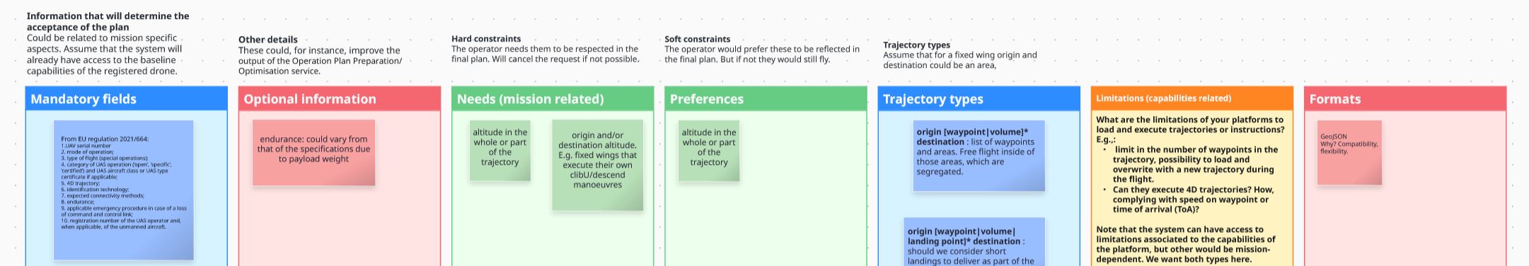
On January 7th 2024, during the first AI4HyDrop Workshop, we invited the participants to contribute with their suggestions for U-plan data and format. We will listen to your feedback along the whole project (around the end on 2025), to reflect your ideas in a final report.

Note that here we want to focus in the flight plan sent by the operators to U-space, not in any dataset that could be shared between services.

To introduce the motivation of the survey, it was explained the case of the project Labyrinth. During it, operators were allowed to submit plans where trajectories would be described as a sequence of points or an area to scan, with the possibility to add some area to avoid.

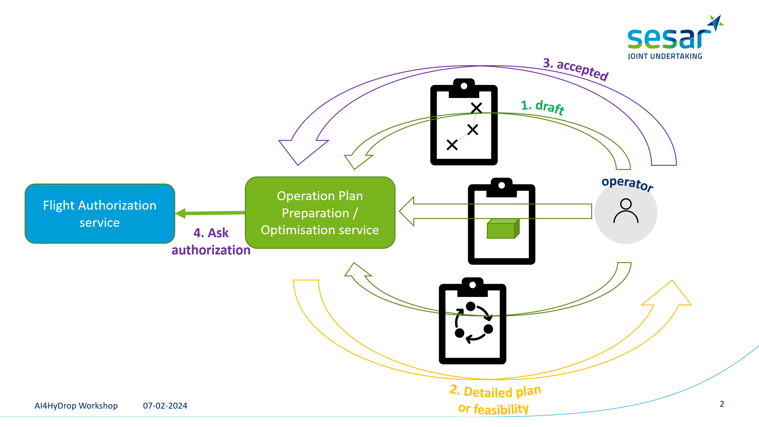
However, during the validations, the final users reported different needs that had to be reflected also in the flight plan, like the possibility to define geo-cages, to fly at a certain altitude, or to define segregated volumes in the origin or destination for the fixed wings to execute their climb/descend manoeuvres. There were also technical limitations and the desire to specify preferences to be allowed if possible.

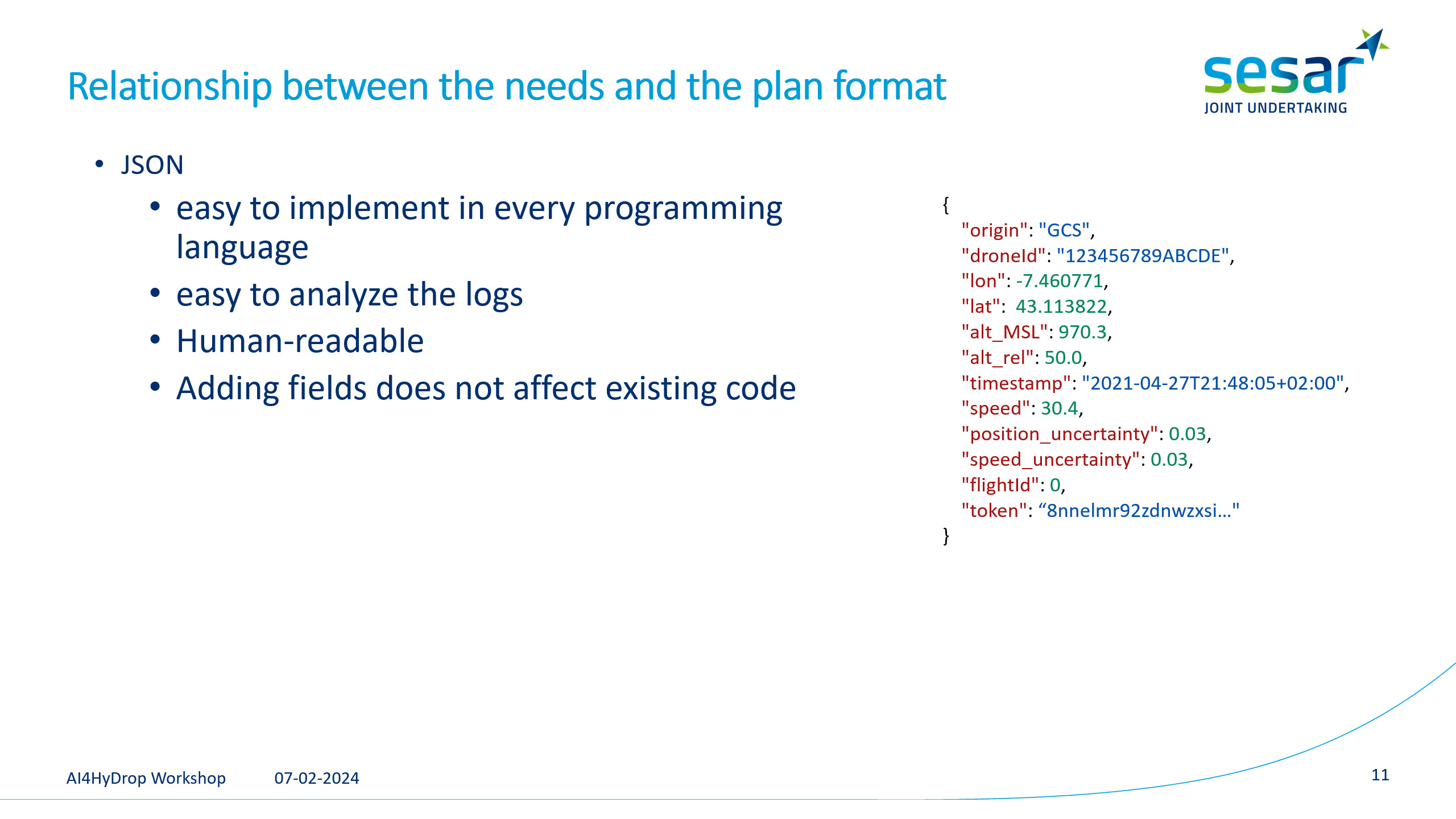
In Labyrinth, it was selected JSON as the format for the messages to communicate with the U-space.


Same as in the project DACUS, Labyrinth selected the GeoJSON standard to represent the flight plans. It allows to describe the trajectories as a sequence of points and areas or volumes.

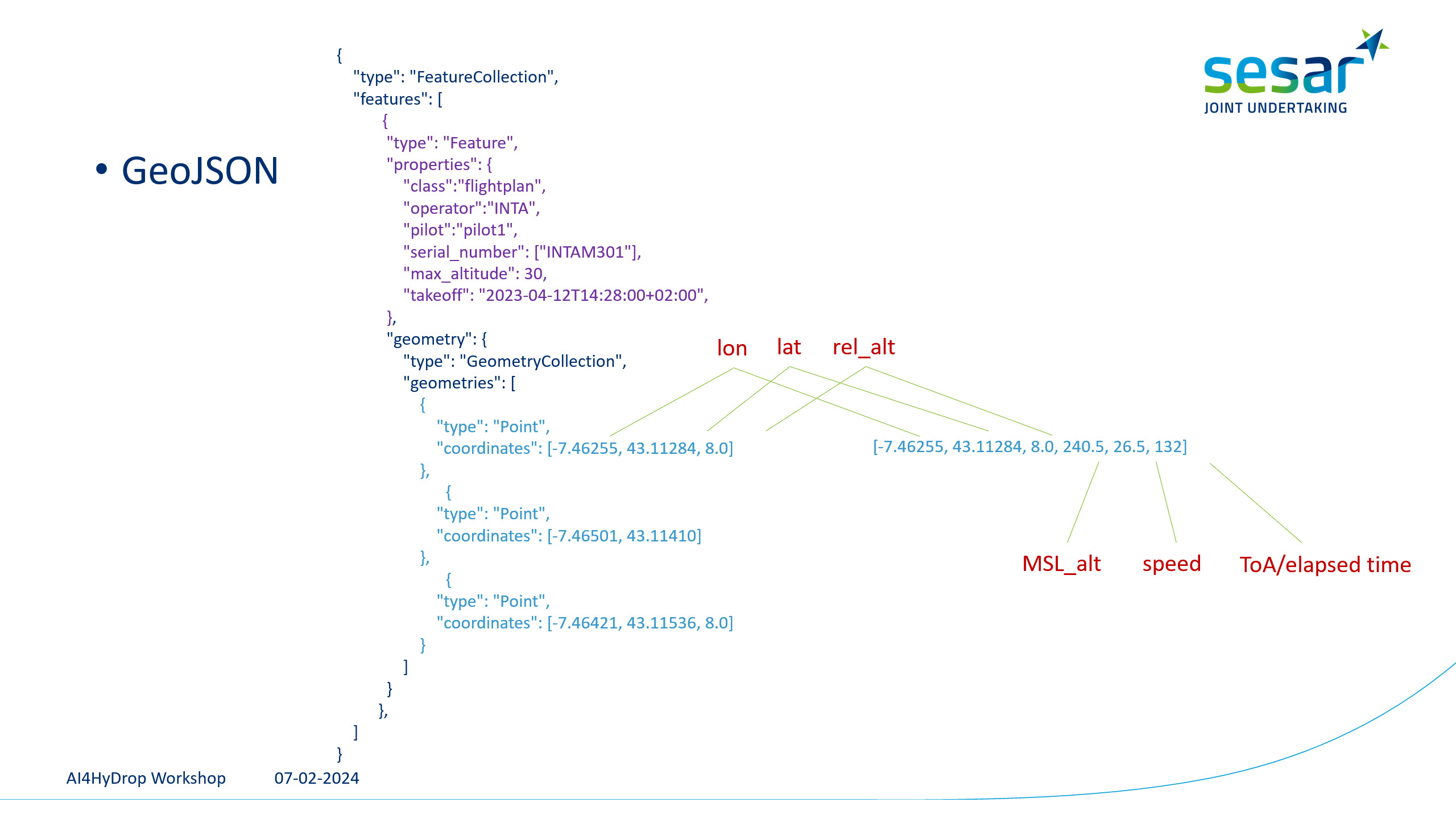
In GeoJSON, a large number or elements can be added to the coordinates, which allows to specify information and constraints associated to the waypoints.

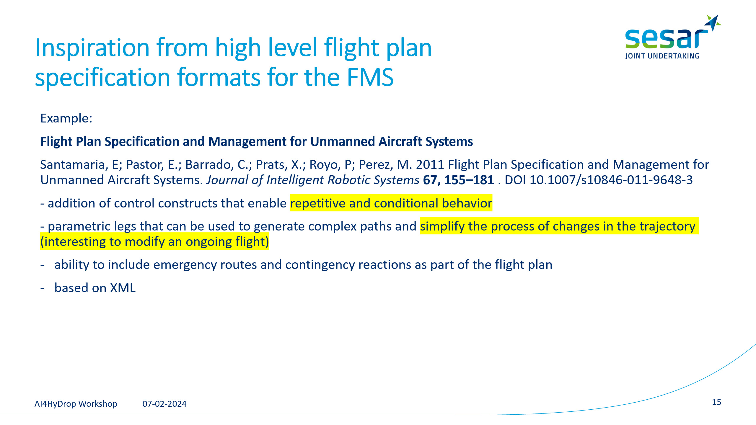
However, inspired by proposals that suggest high level flight plan specifications, we could consider the possibility of using plans with the capability to reflect complex parts like conditions or loops.

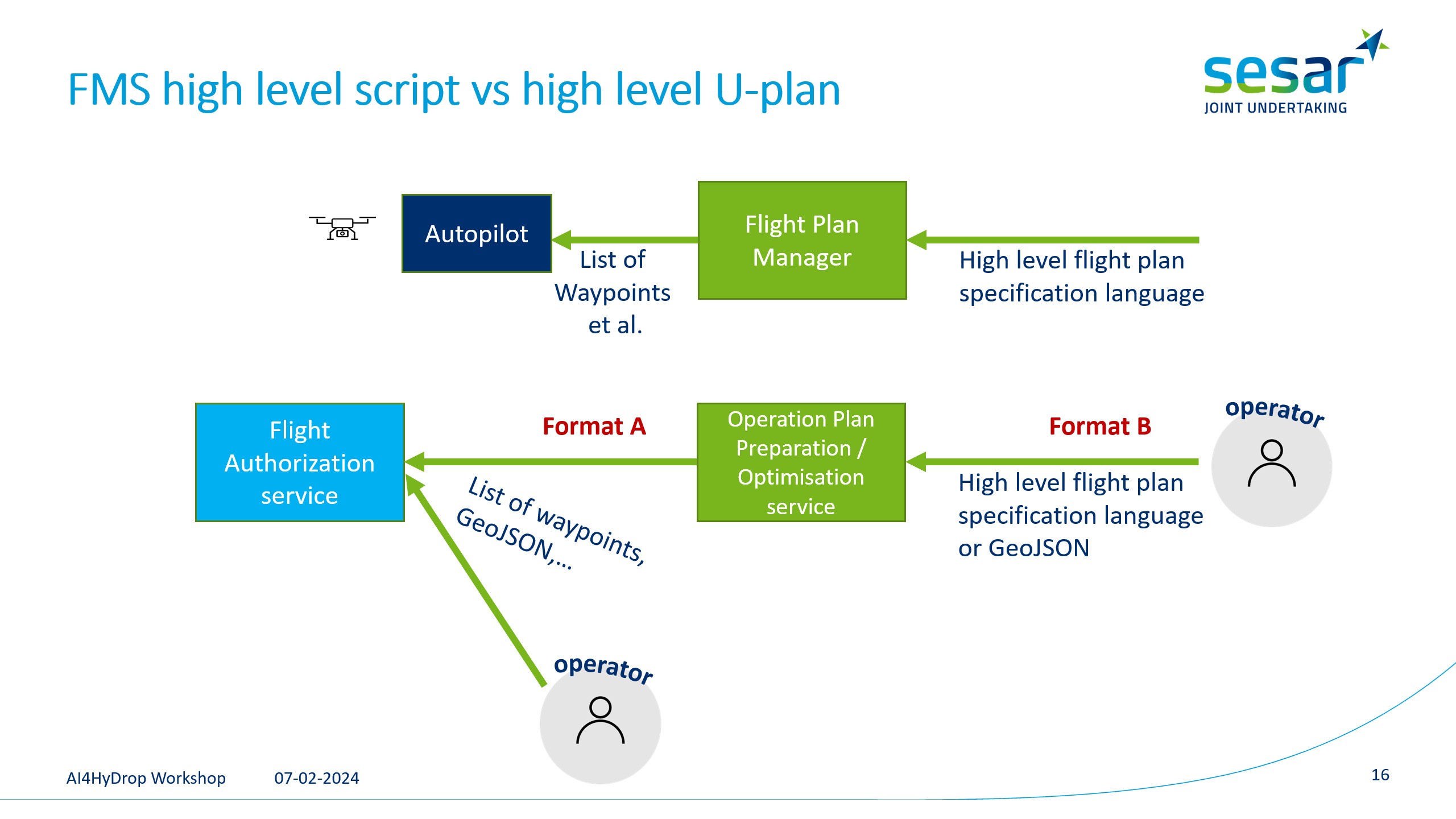
The article in the slide was suggesting a high-level format that would be translated into a list of waypoints to be uploaded to the drone. In our case, a similar high-level specification could be sent to the Operation Plan Preparation/Optimisation service, which would convert it to a more low-level format to be processed by the Flight Authorization service. In the event that the Operation Plan Preparation/Optimisation service is not available, the option to directly send a simpler format should be possible.

All this is just a suggestion and we want to hear your feelings about the existence of both formats and what details or semantics would you need to be reflected on them.

Add your contributions to the following board (choose Guest, write any random name, and then you will be able to add sticky notes)

or just write to us: MiguelAngel.FasMillan@dlr.de


Some needs are only identified when final users create their missions for real flights, that is why your feedback is important us!


1st Workshop for requirements elicitations

📅The first workshop of the AI4HyDrop project was held last Wednesday 7th February of 2024 (online event)
The main objective of the workshop was to discuss with the different stakeholders of the project the main activities that are being carried out, and to collect feedback with their comments and suggestions.

The workshop was attended by more than 70 participants, which was a great success! 🎉🎉

✏️The workshop started with a first plenary session with a general introduction of the project by Professor Aurelie Aurilla Bechina Arntzen from the University of South-Eastern Norway and PO Cengiz ARI from SESAR 3 Joint Undertaking
The workshop was then divided into three parallel tracks that were held twice each so that attendees could participate in more than one session. The sessions were:

✨Session 1: How could the design of airspace and its structure accommodate UAS operations?
Led and moderated by yannick Seprey (Sopra Steria) and NURULLAH GÜLTEKİN (dhmi – General Directorate of State Airports Authority)

✨Session 2: How to Detect and Identify Drones in restricted areas?
Led and moderated by Enrique Puertas (Universidad Europea) and Aurelie Aurilla Bechina Arntzen (USN)

✨Session 3 :How can AI Transform the Automation of Flight Plan Approval Processes?
Led and moderated by Miguel-Ángel Fas-Millán (German Aerospace Center (DLR)) and Emre KOYUNCU (Istanbul Technical University).

The three sessions have provided us with useful insights 📊📈from the stakeholders, which will allow us to take the next steps in the project with valuable information about the requirements and the point of view of the organisations and people who are related to areas related to the tasks of the AI4HyDrop project.

1st Workshop of the AI4HyDrop project will take place on February, 7

🗓️ The 1st Workshop of the AI4HyDrop project will take place on 7 February 2024 from 9:30 to 12 noon (virtual meeting).

During the workshop, you will have the chance to learn firsthand about the cutting-edge technologies, methodologies, and innovations that we are developing within the AI4HyDrop project. Furthermore, it will serve as a platform to engage in meaningful discussions, share experiences, and explore potential collaborations with fellow stakeholders. We believe that your presence and active participation will greatly enrich the workshop and contribute towards the project’s success. Your expertise and insights are highly valued, and we look forward to hearing your perspectives during the interactive sessions. This workshop presents an opportunity for us to gather and exchange valuable insights on the project’s advancements, challenges, and future prospects.

The workshop will have a plenary session and three parallel tracks about design of airspace structure, drone detection, and automatization of drone operations using Artificial Intelligence:

AGENDA

Each track will be held twice to allow people interested in more than one topic to attend.

09:30 Plenary session. Introduction to An AI-based Holistic Dynamic Framework for a safe Drone’s Operations in restricted and urban areas.
10:00 Session 1: How could the design of airspace and its structure accommodate UAS operations?
Session 2: How to Detect and Identify Drones in restricted areas?
Session 3: How to support the automation of Flight Planning? Is AI the next thing?
10:45 Session 1: How could the design of airspace and its structure accommodate UAS operations?
Session 2: How to Detect and Identify Drones in restricted areas?
Session 3: How to support the automation of Flight Planning? Is AI the next thing?
11:30 Sharing of conclusions and discussion on next steps

Session 1 – Design of airspace structure.

Chair: Yannick Seprey (Sopra Steria) / Nurullah Gültekin (DHMI – General Directorate of State Airports Authority)

Airspace design over urban areas, including close to ATM controlled airspaces, will be key to ensure safety of all kind of operations (manned and unmanned/crewed or uncrewed), of people on ground embedding social considerations; That will also provide the proper environment and conditions for airspace users to perform their missions as expected.

This session aims at challenging some ideas AI4HyDrop already has on the subject, collecting ideas from the audience and at answering questions we have on the way to build an airspace design conceptual framework.


Session 2 – How to Detect and Identify Drones in restricted areas?

Session chair: Enrique Puertas (European University in Madrid) / Fabio Suim Chagas (University of South-Eastern Norway)

In this session we will discuss the use of Artificial Intelligence to detect drones flying in no-fly areas within urban areas, discussing the constraints such as the use of low-cost sensors, where to place those sensors and how to train the algorithms with the reduction of false positives in mind. Some of the aspects we want to clarify in this session are what kind of signals and sensors can be suitable for detecting a drone, and which of them can be realistically used in cities and urban environments.

The session will also discuss the different mechanisms to identify the drone operator flying in a restricted area, and how to communicate with him to correct the situation.


Session 3 – How to support the automation of Flight Planning? Is AI the next thing?

Session chair: Miguel A. Fas-Millan (DLR – German Aerospace) / Emre Koyuncu (ITU – Istanbul Technical University)

In this session, we delve into a crucial aspect of AI4HyDrop – the automation of the flight plan approval process. This intricate process entails the management of a vast array of information, including environmental data, policies, priorities, and traffic density balance. We value your insights on the optimal level of transparency, independence, and safety when distributing this information to airspace users.

Furthermore, during this session, we aim to tackle several key aspects:

  1. Defining and structuring pre-tactical flight intentions and plans.
  2. Determining the mandated format for flight plans.
  3. Identifying the information necessary for an automated AI system to assess flight plans in real-time, considering risks, safety, and fairness.

Our goal is to enable efficient and secure U-space management by automating the approval and rejection of flight plans, and your input in shaping these processes is highly valued.


We invite you to participate in this exclusive event. Join us to explore the latest advancements in the utilization of AI for future drone operations at scale in urban and restricted areas.

🔗 To secure your spot, we kindly request you to register promptly through the Eventbrite platform by following the registration link provided below.


🎟️ Registration Link: https://www.eventbrite.es/e/ai4hydrop-workshop-tickets-798303476187


Media and event documents

This section provides you with an array of visual and informational resources, enhancing your experience and engagement at our events.


RollupAI4HyDrop


AI4HyDrop Project present at SESAR Innovation Days

At SESAR Innovation Days 2023, we presented our AI4HyDrop project through an informative poster, engaging with industry experts and aviation enthusiasts to showcase our innovative approach to U-Space management using AI.
As SESAR Innovation Days #SIDS23 concludes, we reflect on the vital role of innovation in enhancing day-to-day operations and future-proofing aviation. The dynamic insights gained at the event fuel our commitment to pioneering solutions in the ever-evolving U-Space and aviation landscape.

Photographs courtesy of Sopra Steria.

AI4HyDrop Kick-off meeting

The kick-off meeting of the #AI4HyDrop project took place on September 27th at the Cuatro Vientos airport in Madrid, coinciding with the Expodrónica Air Show event, which was part of the Airspace Integration week. This meeting provided a great opportunity for all partners to familiarize themselves with the details of all project tasks, establish relationships, and lay the foundations for successful project development.

AI4HyDrop (An AI-based Holistic Dynamic Framework for safe Drone Operations in restricted and urban areas) is a project co-funded by the SESAR 3 Joint Undertaking initiative that assesses the diverse needs of stakeholders, providing validated concepts and defining a methodology for the organization of an airspace structure and the associated services of U-space. The framework will use Artificial Intelligence models and will consider information from other services such as meteorological and separation, which could be used for flight planning approval and priority establishment. Moreover, essential elements like surveillance and contingency planning will be considered.

All consortium members had the opportunity to present their tasks and work packages and exchange valuable information regarding the planning and organization of the work with the SESAR 3 Joint Undertaking delegation.


From this point onward, the focus is on exploring solutions that enhance the U-Space in European territory using Artificial Intelligence techniques. We invite you to follow us and stay updated on the developments we will publish over the next 30 months.